

One out of every two passengers checks the moving map during their flight, making it the most popular feature in the in-flight entertainment library. That’s why companies like FlightPath3D, Gotham Studios, Lufthansa Technik, Panasonic Avionics and Wcities are vying to push the map’s boundaries with geotainment and monetization layers.
Interactive UX
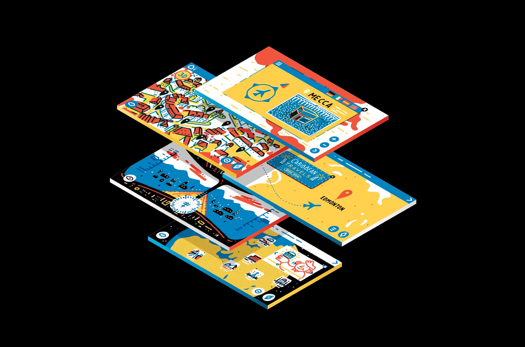
Gone are the days of idly watching a pixelated plane inch frame-by-frame along its flight path. Travelers can now pinch, zoom, pan, tilt, rotate and scroll through ultra high-definition interfaces – whether on personal device-based web portals, seatback screens or handsets. Collins Aerospace’s Airshow mobile app, for example, transforms personal devices into portals to the world beyond the cabin. Spire-hopping over a 3-D cityscape of Prague and aerial reconnaissance of Mount Kilimanjaro’s topography are now closer than ever before to a passenger’s fingertips.
A Different View
No window seat, no problem thanks to maps that offer a range of popular vantage points. Lufthansa Technik’s “niceview” map allows the cockpit visits of yesteryear to be substituted with virtual tours, augmented with on-screen flight data and gadgetry. FlightPath3D allows passengers to choose from among 2-D map views, themed maps, 360-degree panoramas or other customizable map modes, and the company’s Where We Fly feature displays an airline’s route network in a bid to secure additional bookings. Travelers considering an upgrade can also spy on premium cabin interiors before they buy.
Entertaining Touchpoints
Pinpoints have been transformed into starting points for rich geotainment experiences, bringing passengers to thousands of destinations with news, guides, slideshows, trivia and even geo-triggered radio shows. Imagine, as Gotham Studios has, celebs leading passengers on guided audio tours of their flight. Walk travelers through destination highlights via Panasonic Avionics’ influencer-driven discovery tool, or FlightPath3D’s social-media-approved Favorite Places lists. Book last-minute tickets to
Céline Dion on the fly with Wcities’ up-to-date event guides.
Delight in the Details
Passengers have long been able to track altitude, air speed, time zone and temperature data, and connected aircraft bring more personal and practical flight details aboard. FlightPath3D includes a Mecca Pointer, so that Muslim flyers know which way to face for prayer. Wcities content is offered in 27 languages, from Slovenian to Spanish. And Panasonic Avionics’ Arc platform greets travelers by name and lets them peruse their flight history and save preferences for future flights. Those with tight transfers can check gate arrival time and connection details, while those dashing off to meetings can take points-of-interest to go in the airline’s companion app.
Purchasing Power
High viewership makes in-flight maps prime real estate for ads, but that terrain has yet to be exploited. Integration with advertising and analytics platforms, such as Panasonic Avionics’ NEXT Cloud infrastructure, makes it easier for airlines to make relevant, time-sensitive offers during the flight. For instance, if a traveler insists on poking around the Caribbean despite being bound for Edmonton, they may be more keen on tropical deals and Bermuda shorts than first gleaned. Passenger information can also inform strategic partnerships, such as FlightPath3D’s deal with Uber, which allows passengers to plan and schedule their airport ride.
“New Frontiers” was originally published in the 9.4 September/October issue of APEX Experience magazine.